
Introducing Zwivel: Instant Aerial Photography at Your Fingertips.
Search our nationwide library of more than 70,000 locations and you control the camera.

ABOUT AERIALSPHERE
360° Aerial Imagery with Precise Location Data
With an experienced team and eight patents, AerialSphere is on a mission to change the way people experience the world from above.
WHY AERIALSPHERE?
Look at location, topography and structure in new ways to make better decisions for your organization.
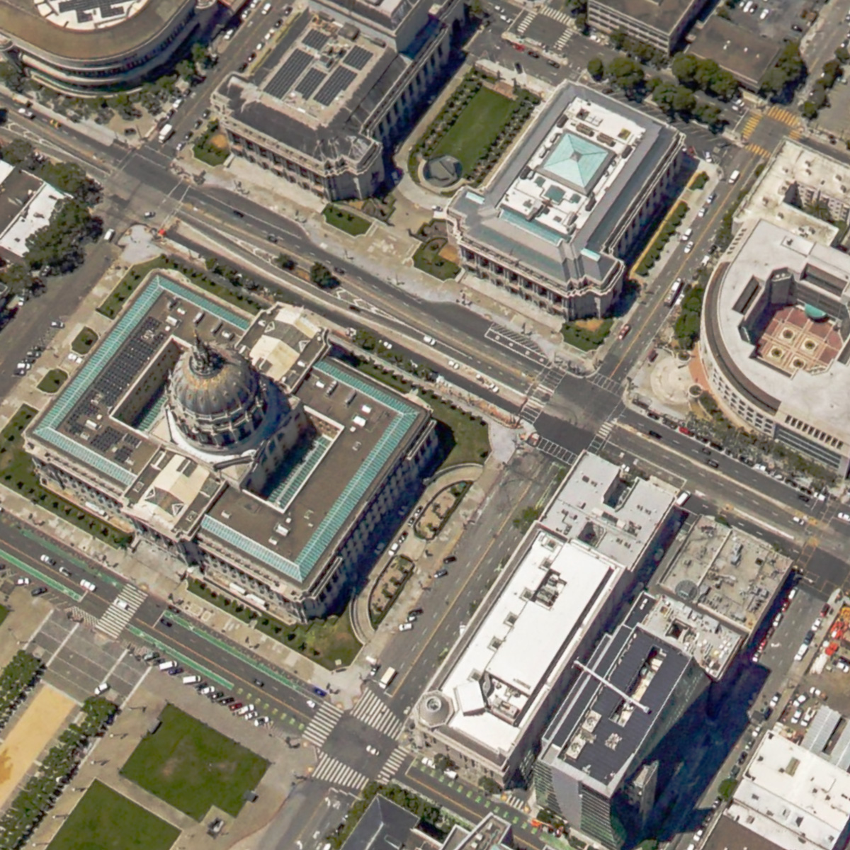
Better than Google Earth
3D polygon representations can be fun, but when your business or product requires any amount of detail in your imagery, there is no substitute for the real thing. AerialSphere captures its own (real) aerial imagery at high resolution so you always have the most detailed perspectives when using our experiences.
See for yourself. Compare the model from Google Earth on the left to AerialSphere’s image on the right.

Differentiate yourself with our unique Perspective
Don’t settle for satellite views or low-poly 3D images from other providers. Put communities and neighborhoods in vibrant, crisp focus using our imagery. We provide real imagery from heights drones can’t reach and a view that is unmatched.
Easily put your data in our imagery
From property listings to third party APIs, our solution allows you to link and visualize a variety of data sources in our viewer. So whether you’re selling commercial real estate or researching new opportunities, our imagery perfectly complements your existing tools.
5X Increase in Website User Engagement
Our own testing has shown a substantial increase in user engagement. By giving customers a birds-eye-view, they will want to stay on your site longer and come back more often.
Industry Solutions
Combining our unique aerial imagery with location data is helping our clients redefine the way they view, analyze and make decisions about the world below.
Real Estate Marketing
From residential to retail, our imagery and software can enhance your marketing and drive user engagement.
GIS Professionals
Easily integrate our imagery into geospatial software to provide an immersive new perspective on your project.
CRM, MLS, IDX & Other Resellers
We have enterprise-level solutions to better visualize your assets and make better decisions for future transactions.
Trusted by the Best
Leaders in all industries are integrating our experiences to add another level of engagement to their products and services.


Extensive Coverage
Imagery in Every Major Market
AerialSphere’s high-resolution aerial imagery spans nearly 80 of the largest markets in the United States. If you desire coverage in an area we don’t already provide, let us know and we would be happy discuss options for attaining that imagery.
Akron, OH
Albuquerque, NM
Allentown, PA
Austin, TX
Bend, OR
Boise, ID
Boston, MA
Charlotte, NC
Chicago, IL
Cincinnati, OH
Cleveland, OH
Colorado Springs, CO
Columbus, OH
Dallas, TX
Dayton, OH
Denver, CO
Detroit, MI
El Paso, TX
Ft. Wayne, IN
Hood River, OR
Indianapolis, IN
Kansas City, KS
Las Vegas, NV
Los Angeles, CA
Louisville, KY
Memphis, TN
Milwaukee, WI
Minneapolis, MN
Mission Viejo, CA
Nashua, NH
Nashville, TN
New York City, NY
Oklahoma City, OK
Omaha, NE
Palm Springs, CA
Philadelphia, PA
Phoenix, AZ
Pittsburg, PA
Portland, OR
Prescott, AZ
Raleigh, NC
Richmond, VA
Riverside, CA
Sacramento, CA
Salt Lake City, UT
San Antonio, TX
San Diego, CA
San Francisco, CA
Santa Clarita, CA
Seattle, WA
Spokane, WA
St. Louis, MO
Toledo, OH
Tucson, AZ
Wichita, KS
Yakima, WA
Want to learn more?
Drop us a line. We’ll happily respond to your inquiry or just keep you up to date with the latest imagery and product offerings from AerialSphere.