Using Aerial Imagery for Disaster Analysis

Natural disasters can have devastating impacts on communities and the environment. Understanding the impact of these events and mitigating their effects is essential for disaster response and recovery efforts. We’re committed to using technology to support disaster analysis. This post will discuss using aerial imagery, specifically the Multi-Oriented Imagery Viewer and Catalogs, to support disaster response and recovery efforts.
Our Multi-Oriented Imagery Catalogs enable us to analyze aerial imagery from different years, providing valuable insights to decision-makers. We’ve created two demos that showcase how we’re using Multi-OIC to support disaster analysis and management:
-
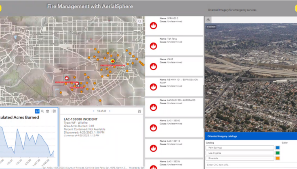
Fire Analysis in California: This demo is a work-in-progress project using the Multi-Oriented Imagery Catalog Widget Viewer (MOICV) for experience builder (ExB). This video provides a closer look at how we use real-time data to visualize wildfires and support decision-making. With MOICV, we could load multiple imagery catalogs for California regions into one project. By interacting with the exposure points, we can load our imagery and tie it to a fire map created using publicly available wildfire data from the Living Atlas in ArcGIS online. The ExB widgets in the middle and bottom panels are tied to the wildfire data, triggering metadata updates and map changes when a fire is clicked.
-
Marshall Fire in Boulder, CO: In this demo, we used Multi-OIC to compare aerial imagery from before (2020) and after (2022) the Marshall Fire in Boulder, CO (2021). The layers added to the map show the structures affected by the fire and the perimeter of the fire. By comparing the imagery from different years, decision-makers can gain insights into the effects of the disaster on the environment and communities.
To view video demos of these please click on the links below:
About AerialSphere
AerialSphere is the only company to combine 360-degree aerial imagery with location data, giving companies new vantage points to make better-informed decisions. Built upon nearly a decade of research and patented technological innovation, AerialSphere is changing how companies plan, develop and market their properties, products, and services.
Our dedication to innovation has positioned us as a driving market force in a number of industries including real estate, government, retail, insurance, and entertainment. AerialSphere has been trusted by four of the top five commercial real estate brokerages and continues to be recognized for its innovative technology.
To learn more about AerialSphere, visit aerialsphere.com.


